Thursday, February 11th, 2016 — 4 PM
This Evening — Clouds building. Temperatures cooling into the 30s late this evening, and then down to the mid to upper 20s after midnight.
Temperatures this afternoon have been about 10° warmer than yesterday, which should melt away most, if not all of the issues remaining on back roads throughout the county. However…
HRRR loop through 5 AM, Friday:

Yet another clipper system (what does that make…3 or 4 this week?) will move through our area overnight/early tomorrow morning. It looks like the bulk of the moisture will remain just to our north over southern Kentucky, but should we see enough slide down our way, it could give us a shot at some minor accumulating snow — like a dusting to a half inch — so not much to be concerned about. The snow could recreate some slick spots in the morning, but warmer temperatures climbing into the low 40s by the afternoon should easily take care of any issues that develop. We could even see a light rain shower or two before the precipitation is all said and done by the late morning hours.
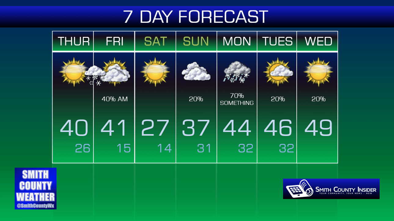
Friday — Snow showers/flurries/light rain in the morning. Mostly cloudy in the afternoon. Wake up: 26°, High: 41°. Winds WNW at 5 to 10 mph.
Temperatures will cool down significantly on Saturday, with our high only topping out in the upper 20s! We’ll recover a bit on Sunday to the mid to upper 30s ahead of our next potential winter weather system, which is already being hyped up by several less-than-reputable sources on social media today. Seriously, if you see snow total maps posted today for Sunday/Monday, ignore them. Here’s why:


Science when predicting snow is…less than perfect, so to speak — especially this far out from the event. Models are literally all over the place with what will happen with Sunday night/Monday’s wintry system.
We’ll discuss two particular models here, the GFS and the Euro. Each paint a completely different picture of what will go down.
THE GFS:
Late Sunday night, precipitation will move into our area, beginning as snow. Less than an inch will accumulate before a transition to all rain occurs by mid morning. A break in the rain may come during the midday before more rain (possibly heavy) moves in for the afternoon and into the night, perhaps transitioning to a brief wintry mix before tapering off completely Tuesday morning.
Total snow impact is minimal.

THE EURO:
Again, precipitation will move into our area late Sunday, lasting throughout the day on Monday. The difference from the GFS? The Euro is painting it as ALL snow, with accumulation totals up there with what we had a few weeks ago. You may have seen a images today of the snow totals map from the Euro (which technically isn’t supposed to be posted publicly for legal reasons…). Ignore these.

Interestingly enough, the Euro indicates temperatures on Monday rising into the mid to upper 30s, which in many cases is too warm for snow to occur. Not saying it can’t or won’t happen, but that’s just one sign to suggest that perhaps the Euro is biting off a little more than it can chew with this system.
So, what’s the verdict?
It’s wayyyy to early to speculate here, so we won’t. But for all intents and purposes, the GFS should probably warrant more attention from us right now, especially with temperatures looking to be several degrees above freezing with both models.
Again, and this can’t be stressed enough, be careful with what you share on social media. The Euro’s snow totals map is spreading like wildfire today, and while it’s certainly not out of the realm of possibility that it could end up panning out, it’s downright irresponsible to spread that map without also explaining the flip side of the coin. When it comes to snow, people tend to get excited over the improbable side of the forecast that they want to hear (big snow) and completely tune out the more likely part (less snow). Don’t be that person.

As we get closer to Sunday and Monday, models will begin to come into agreement, and we’ll have a better hold on what may happen. That’s when we’ll begin speculation. For the next day or two, however, we’ll be taking matters with a huge grain of salt. You should, too.
Note: the official National Weather Service 7 day forecast (which we pull our data from for our 7 day graphic, below) has a high of 44° listed for Monday. That is not a set in stone forecasted high, so take that for what it’s worth.
Extended: