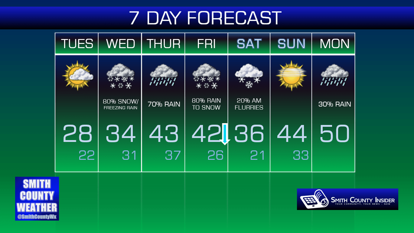
Tuesday, January 19th, 2016 — 2:55 PM
This Evening — Increasing clouds. Cold. Temperatures in the 20s. Winds NNE at 5 mph.
It’s cold, and that’s about all there is to say about this evening. Tomorrow is the center of our attention.
A Winter Weather Advisory is in effect for Wednesday between Midnight and 6 PM.

The National Weather Service believes anywhere from 1 to 3 inches of snow accumulation will be possible, primarily tomorrow morning, with an additional 1/10th of an inch of ice accumulation possible, if/when the snow transitions over to freezing rain. According to the text of the advisory: “major travel impacts are possible.” It goes on to say that an upgrade to a Winter Storm Warning might be necessitated.
As we stated yesterday, there are multiple variables at play here, and one slight difference in temperature either here at the surface or a few thousand feet above us (or somewhere in between) can make all the difference. Right now, precipitation looks to begin sometime around daylight or just before. With temperatures still several degrees below freezing at that time, any precipitation that falls will most likely be in the form of snow and will cause immediate travel impacts, especially on back roads that haven’t been treated. As we go through the late morning hours, temperatures will begin to rise a bit, especially up above us, allowing for a transition to rain to occur. If rain begins to fall with temperatures here at the surface still below freezing, then lo and behold, ice will form. We could potentially see up to a tenth of an inch of ice accumulation — not enough to down tree limbs or power lines, but enough to add an extra slick glaze to road surfaces. If any precipitation remains by the time temperatures finally climb above freezing here on the surface, then we’ll see a transition to just plain rain before all is said and done.
A couple of things to note about all of this:
Confidence is pretty high that we will see accumulating snow to kick things off tomorrow morning. What remains uncertain, however, is how quickly temperatures will rise and the correlation with falling precipitation. The above scenario seems the most probable with what models are currently indicating, but as with any winter weather forecast, that is subject to change. It’s possible we’ll only see snow, and by the time temperatures have risen enough for a transition to freezing rain/regular rain to occur, all of the precipitation will be out of our area, leaving us with 1 or 2, maybe up to 3 inches of the white stuff to play in. Conversely, temperatures could rise a bit faster, allowing for a transition to freezing rain to occur before much snow can accumulate, and then a transition to all rain before it’s all over with — helping the melting process and probably clearing roads by the afternoon. We’ll have to wait and see. At least as we get closer to the event, models should come into better agreement on things and give us a much clearer and more specific picture on what will happen.
We recommend that you consult with multiple *reliable* weather sources over the next 24 hours as this event unfolds.
As far as whether schools will be delayed or closed, we don’t have that information right now. If/when a decision is made, we’ll try to pass that information along to you as quickly as possible. It’s probably a safe bet that there will an announcement made at some point by tomorrow morning (perhaps as soon as this evening) given the way things are trending, but that’s purely speculation on our part.
So, that’s how our Wednesday is shaping up. Is that it? Nope. There’s more…

Wednesday’s system looks to be a fast mover, exiting our area by the afternoon hours. Temperatures will hover around freezing in the low 30s overnight heading into Thursday morning.
Yet another system will begin to work its way into our area during the day on Thursday. With temperatures in the low 40s, precipitation this go-around will be in the form of rain — which will help melt away any lingering problems that may exist from Wednesday.
GFS — 6 AM Friday Morning:
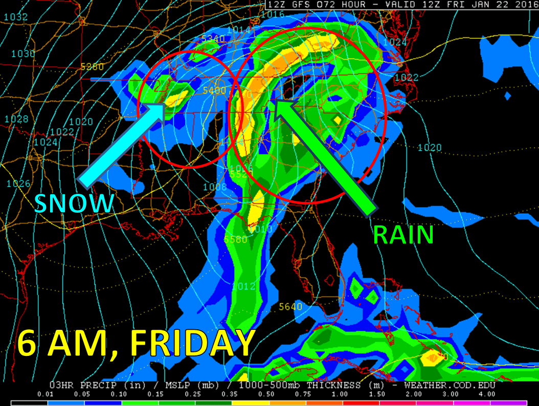
As this low pressure systems slides through, colder air will rush in on the back side of it overnight Thursday into Friday morning, allowing for precipitation to transition to all snow. Currently, indications are that this will be a smooth transition with few worries of freezing rain (ice formation). Snow accumulations appear likely with this event, with snow showers possible all day Friday, perhaps lingering into our Saturday. It’s too soon to talk total accumulations, but a couple of inches doesn’t look to be out of the question — perhaps even more. Again, things can and will change between now and then, so stay tuned for later updates and consult with multiple other reliable sources over the next couple of days.
Any problems that Friday brings, particularly with roads, should be eradicated on Sunday with temperatures expected to climb into the mid 40s with some sunshine. We’ll have keep an eye on next week as this unsettled weather pattern continues, as we could potentially be looking at yet another chance for snow — but that’s still a long ways off to be at all concerned about it. We have enough on our plate to deal with as it is.
Extended: