Saturday, January 30th, 2016 — 11:45 PM
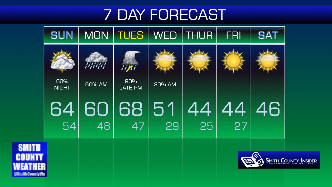
Sunday — Mostly cloudy skies. Showers becoming possible late in the afternoon/evening. Wake up: 50°, Afternoon high: 64°. Winds SSW at 10 to 15 mph, with gusts up to 20 mph.
Our Sunday looks pretty good for the most part, but it will be a bit on the windy side thanks to a strong SSW breeze gusting up to 20 mph at times. We’ll see more cloud cover around than we saw on our Saturday, as well.
NAM 4km — 7 PM:

Rain will begin to filter into our area after sunset, with scattered showers likely on and off through at least our morning commute on Monday — perhaps lasting until the noon hour before tapering off.
NAM 4 km — 9 AM, Monday:

Because of the morning showers and increased cloud cover, temperatures on Monday will be held down a little from where they were over the weekend, with our high only topping out at around 60°, which is still more than 10° above average for this time of year, so it’s tough to complain about that.
All of this unseasonably mild weather will have to come to an end at some point, and indeed, Tuesday looks to be the end of the line. And the warmth might not go away all that quietly, either…
Storm Prediction Center ‘Day 4’ Severe Weather Outlook:

When SPC released their latest severe weather outlook early Saturday morning, they pushed the ‘30% risk area’ a little to our west for severe weather within 25 miles of any given point, giving us a ‘15% designation’. This doesn’t mean we are out of the woods for severe weather, but it looks like most of the action will take place over parts of West Tennessee, northern Mississippi, and southwestern Kentucky during the afternoon hours of Tuesday, when instability will be at its greatest. It’s looking like a squall line will move through our area sometime late Tuesday night, with damaging winds looking to be our primary concern, although an isolated tornado or two along the line cannot be ruled out.
We’re a few days out, so there is still time for models to change their minds on what will happen. What we don’t want are individual supercells out ahead of the line late Tuesday afternoon/evening, which won’t have any other storms to compete with for energy. Those are the ones that put down strong tornadoes (think December 23rd near Lancaster). Right now, it doesn’t appear likely that we’ll have to worry about that.
Once newer model runs come in closer to the event, we’ll have a better idea of how exactly things may shape up.
This isn’t a situation that warrants a great deal of worry or panic, but you shouldn’t ignore it, either. Stay tuned for later updates as they become available and check with multiple reliable weather sources as we get closer to Tuesday. You can follow along with Smith County Weather on Facebook and Twitter for the latest updates.
Once we get past Tuesday, we’ll cool back down to more normal levels. It is still winter, after all…
Extended: