


Wednesday, March 30, 2016 — 4:53 PM
This evening — Cloudy. Showers becoming possible late.. Windy. Temperatures in the 70s. Winds S at 15 mph, gusting over 20 mph.
We started out with a gorgeous sunny sky, but clouds ahead of tonight/tomorrow’s storm system brought that to an end around lunchtime. With a rather strong wind out of the South, our temperatures have soared from around 40° this morning into the mid 70s this afternoon.
Winds will continue to be on the gusty side through this evening, but we should remain dry through at least 8 or 9. Any outdoor activities scheduled for this afternoon and evening should be good to go.
HRRR loop through 6 am Thursday:

HRRR shows some light to moderate shower activity filtering in late this evening. We’ll have to wait and see as to whether that will materialize or not, but we do know for sure much heavier rain and even thunderstorms will move in early in the morning. The above run of the HRRR model suggests the rain should be here just in time for our morning commute, so be very careful on your way to work in the morning, as water will quickly begin to pond on roadways, potentially leading to flash flooding concerns later in the day (more on that below).
Okay, so before we go any further, let’s go over something…
Science isn’t perfect. The models the weather enterprise look at to determine what may happen in the future are generally pretty good. But they aren’t great and are certainly far from perfect. Even our really awesome short range models [the High Resolution Rapid Refresh (HRRR) in particular] aren’t infallible. Sometimes they can overdo a storm system by showing much more than what will actually happen, and sometimes they will downplay an event. Other times, they may either completely miss something or show something and nothing happens. It’s what we have to work with, and for the most part, they get the job done pretty well.
In the case of tomorrow, we’re not quite sure what to think of the models (the NAM 4km in particular, which we’ll get to in a moment). Tomorrow will be a day where we probably won’t have a good hold on what’s to come later in the day and evening until other factors that the models are currently struggling with play themselves out, and even then, uncertainties may still exist.
Again, science.

Storm Prediction Center Day 2 Outlook:
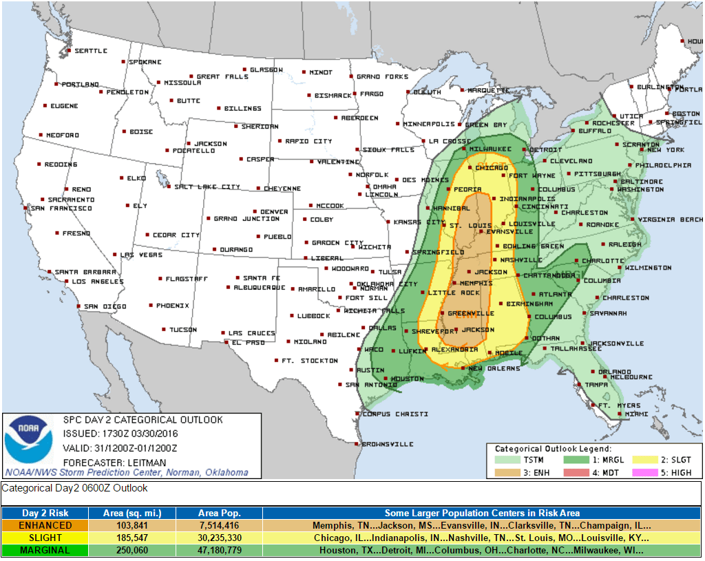


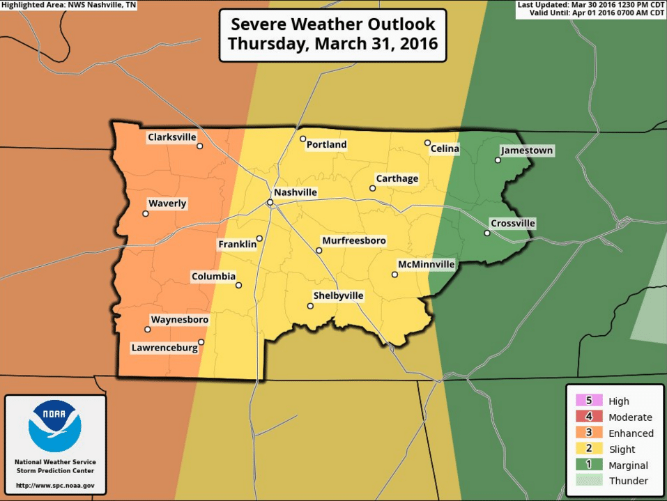

The Storm Prediction Center has placed our area in a Slight Risk for severe weather tomorrow. Unlike with our previous two Slight Risk days, which each ended up being duds for various reason (mainly: lack of ‘stuff’ needed for severe storms to form), the ingredients needed for severe weather, even significant severe weather, could potentially be in place — almost totally dependent on whether a couple of key factors play out just right.
Let’s go back to those morning showers and thunderstorms…

Similar to the HRRR, the NAM 4km is suggesting a mid morning arrival time for our first batch of rain and storms. We are currently not expecting any severe weather with this first round. Heavy rain is going to be our primary concern, as stated above. There may also be a few rumbles of thunder mixed in.
When exactly this first round of rain moves out will likely play a significant role in how our severe storm chances shape up later in the day.

The NAM 4km (above) shows the storms moving out at around lunchtime. This is an approximation.
Also of note: it seems to want to fire new cells, perhaps supercells, as early as 1 pm. This seems a little too soon, but it’s something we’ll watch.
If the storms move out during the late morning hours, that will allow more time for the atmosphere re-prime itself for severe weather between the late afternoon and evening. However, if the storms linger around into the early afternoon hours, that will limit how much the atmosphere destabilizes.
Also, if there are storms to our south in the afternoon, that will limit the flow of that rich Gulf moisture and warmth storms like to feed on.
And clouds… If we see an abundance of cloud cover and little to no sun in the afternoon, then that will also limit our severe potential substantially.
So yeah… Those are just some of the factors that would greatly limit our potential for severe weather later in the day and evening.
Now, what all would need to happen in order to have a pretty substantial severe weather event?
These are just a few factors…
- The morning storms will most likely need to be about by noon. The later we clear out, the less our severe chances will be. The sooner, the greater our chances.
- Sunshine. Storms absolutely love the sun. We will likely see a long break in the rain once it moves out, but that doesn’t mean we will see much in the way of sun. However, there is reason to suspect we may see a break in the clouds and some sunshine. The more sun we see, the more we’ll warm up, and the more fuel storms will have to work with.
- We’ll need a fairly open path to the Gulf of Mexico. If there is a complex of storms lingering over northern Alabama or southern Middle Tennessee tomorrow afternoon, that Gulf flow will be cut off, greatly limiting our chances of destabilizing later in the day.
- CAPE (convective available potential energy) will need to be on the high side, which is possible if the above factors happen.
- Assuming all of the above happen, storm cells will probably need to form before we start losing the juice daytime heating brings with it. Before sunset would be ideal or shortly thereafter. Any later, and the ingredients might not be as favorable. But with that being said, that doesn’t mean we can’t have severe weather after dark. It’s happened numerous times before.
There is no guarantee that any of the above will happen, hence why the Storm Prediction Center is only going with a Slight Risk for us for right now. Quite honestly, we likely won’t know for sure how exactly our severe weather threat will pan out until late tomorrow morning or even as late as tomorrow afternoon. You need to stay weather aware as we head into tomorrow. Yes, there is recent precedent for Slight Risk days to not pan out at all, but tomorrow is much different. SPC may very well upgrade that risk sometime tonight or tomorrow. The Smith County Weather page on Facebook and Twitter (especially Twitter) will be posting updates throughout the day, so make sure to follow along for the latest information.
What do the models think will happen?
Without getting too deep into specifics, the NAM 4km has been very…aggressive…with tomorrow evening’s storms, to say the least. If it verifies, then we may have some issues. Fortunately, this particular model has a history of over-doing severe weather intensity, but for what it’s worth, it has been fairly consistent with favoring a pretty rough go of it tomorrow evening, with pretty much all forms of severe weather on the table, including tornadoes. We’ll see.
Other models aren’t quite as aggressive, but they are also more long range than the NAM 4km and HRRR, so they may not pick up on every little detail the shorter range models can.
Again, this is largely going to be a ‘wait and see’ event, so follow Smith County Weather and have a way of getting notified of alerts tomorrow.
In addition to severe weather, we also may have flash flooding concerns to deal with, particularly with the afternoon/evening storms. Heavy rain falling on already saturated ground from the morning storms will have a tough time being absorbed into the ground and may cause flash flooding in some areas, so be aware of that tomorrow.
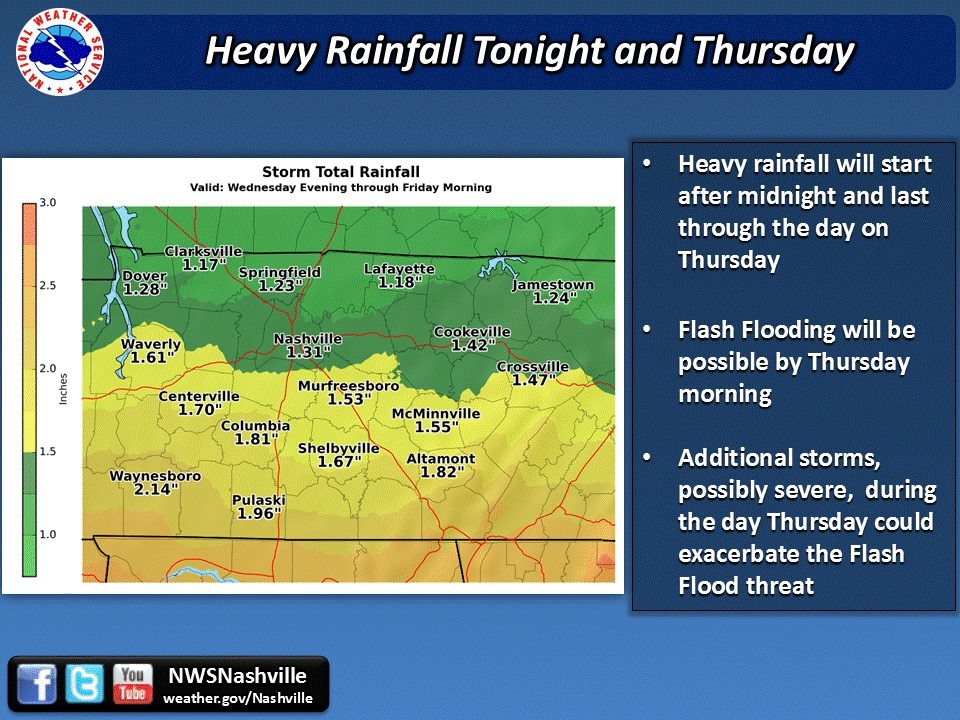
The National Weather Service thinks anywhere from 1 to 2 inches of rain will be possible in all tomorrow.
This is a lot to take in, yes, but we want you be as prepared as possible for whatever may come our way tomorrow. Again, updates will be posted all day on Smith County Weather, with live updates should we have a severe storm, so be sure so follow along for information and stay aware of what’s going on.
While the severity of tomorrow’s storms may be difficult to determine right now, we can say with much higher confidence that we should dry out by Friday morning, with clouds steadily decreasing throughout the day. This weekend will be cooler with highs only in the lower 60s, but we will be dry and very nice, with sunny skies both Saturday and Sunday!


