


Tuesday, April 26, 2016 — 12:03 pm
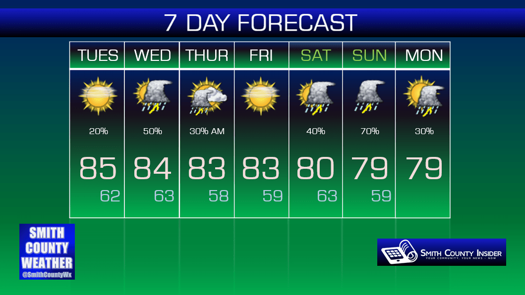
This Afternoon — Mostly sunny. A stray shower/t-storm possible. High: 85°. Winds SW at 5 to 10 mph.
It’s going to be another warm afternoon with summer-like temperatures more than 10° above average. And just like on a typical summer day, we could see a pop up shower or thunderstorm this afternoon. It probably won’t happen, but it’s not out of the question.
Now, late this evening, on the other hand…
HRRR loop through 1 am:

First, HRRR is pretty aggressive with scattered showers and thunderstorms popping up across the midstate this afternoon, but current radar trends are negating that. Again, we’ll stick with only a small chance of seeing a shower or thunderstorm this afternoon.
Late this evening, however, HRRR shows a weakening area of showers and thunderstorms moving down from the northwest around 11 pm or so. It looks to be late enough that it won’t affect any ball games or practices, and no severe weather is anticipated with this round of storms.
And one thing of note, the NAM 4km model has nothing moving through this evening…

Instead, it shows the storms moving much slower and likely falling apart before they make it here. Which model will win? We shall see.
Wednesday — Probably dry most of the day. Showers and thunderstorms becoming more likely late. Wake up: 62°, High: 84°. Winds S at 5 to 10 mph.
Tomorrow looks mainly dry. The GFS is favoring a wet morning, but the NAM 4km favors us being dry. More than likely, we’ll be dry for much of the day, but again, we shall see.
Things will really begin to get complicated as we head into the evening.
First…
SPC Day 2 Oulook:

The Storm Prediction Center has outlined us in a Marginal Risk for severe weather Wednesday. This is really looking to be more of a threat for Wednesday night/early Thursday morning based on current model trends, but some of the ingredients for severe storm development may be in place tomorrow afternoon, and if a storm were to pop up, it’s not totally out of the question that it could go severe.
In any case, this is a low end severe weather threat.

The tomorrow night/Thursday morning time frame is what has our attention right now. Again, the severe threat is only Marginal right now, but at least one model (NAM 4km) thinks there could be some meat there. We’ll have to wait and see if these trends continue and what the Storm Prediction Center has to say in later outlooks.
If we do see storms Thursday morning, they should be out by the afternoon, setting us up for a nice evening, with dry conditions carrying over into Friday.
This weekend…not looking so good.
Extended:
Pollen Outlook:

Pollen counts will remain on the high side through Thursday, unfortunately.


