


Wednesday, December 23rd, 2015 — 2:46 PM
The following text was posted on Facebook and has been edited for this page. Follow along with Smith County Weather on Facebook and Twitter for the latest severe weather updates, as that information will not be posted here.

Earlier today, the Storm Prediction Center upgraded us to Moderate Risk status for severe weather this evening, or a 4 out of 5, if that gives you a better idea.
We haven’t had a setup quite like this since probably March 2nd, 2012. That day saw a few tornadoes across the mid-state, although we ended up getting lucky, with the really bad stuff being contained to our north over areas of Kentucky and Indiana.
Several things of note here:
1) It’s been cloudy all morning. A few people have pointed this out. This time of year, however, sun isn’t all that much of a factor for storm formation like it is the Spring or Summer months. Also, the sun is trying to come out at the time of typing this, and that’s not good.
2) Virtually all of the ingredients needed for severe weather, including tornadoes, are in or are expected to be in place this evening.
3) Models have been continuously showing a favorable environment for severe weather the past few days, and that still holds true.
This isn’t a day to mess around with. Yes, yes… Christmas is in two days. We implore you, though… Please, you shouldn’t go shopping this afternoon or evening if you can avoid it at all. Remember the Gallatin tornado in 2006? Remember the Murfreesboro tornado in 2009? This is one of those days. We may not have a tornado like that, but the atmosphere is priming itself for it.
Going back to that Moderate Risk, there are several sub-categories for types of severe weather. Let’s go over them…
All of these percentages are the chance of the given even happening within 25 miles of any location:
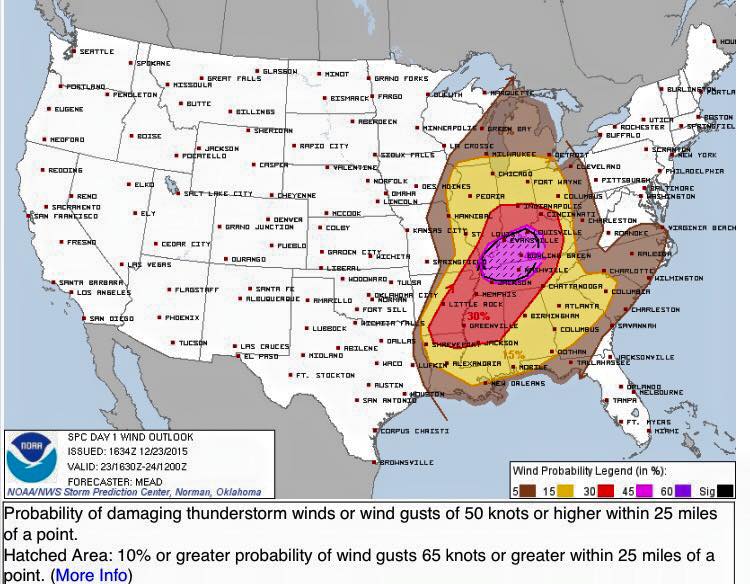
There is a 45% chance of damaging winds in excess of 58 mph, with a 10% ‘hatched’ area for substantial winds in excess of 74 mph — something that doesn’t happen very often.
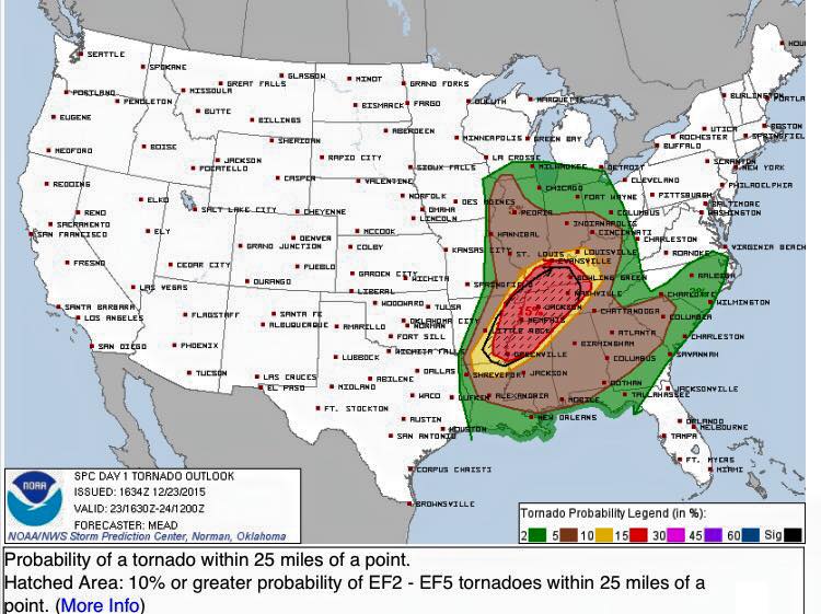
There is a 15% chance of tornadoes, with a 10% ‘hatched’ area for **violent** tornadoes rated EF-2 to EF-5 (very rare for us).

There is a 5% chance of large hail. Not very high, but worth nothing.
These chances should not be taken lightly. The time to prepare is now. If you live in a mobile home, you should be making arrangements to stay somewhere safer this evening until the all clear is given. Make sure your weather radios have fresh batteries and are set to the proper channel (162.525 MHz) and ready to go off when an alert is issued. If you have an alert app, make sure it is set to go off for your location.
Timing of these storms will be late this afternoon through at least 10 PM, possibly up to midnight. We’ll see a squall line towards the end of the duration, but what we’re really concerned with are discreet, supercell thunderstorms that can pop up at any time, anywhere. All storms will be moving from SW to NE, and they’ll be booking it at speeds close to 60 mph — so fast that warning time will be at a minimum, so keep that in mind if you receive an alert later. Because supercells are so unpredictable, we can’t give a time for when they will happen. It does look like those later evening hours, like maybe 7 to 9-ish, will be most favorable, but that’s just an estimate.
We’ll get through this. It’s a busy day as it is, and severe weather just isn’t one of those things on people’s minds, but you have to pay attention today. We don’t like over-hyping potential severe weather situations and try to avoid it whenever possible, but today deserves our up-most attention.
More updates will be posted throughout the afternoon and evening on our social media channels, although more stuff will be posted on Twitter (@SmithCountyWx), so follow along there if you can — especially if you want up-to-the-minute(or even second) radar updates and greater commentary than what will be posted on Facebook.


