


Monday, December 21st, 2015 — 12:41 PM
After a brief return over the weekend to what our temperatures *should* be this time of year. we once again find ourselves soaring right back up to those unseasonable levels we’ve grown so accustomed to lately. Looking at the forecast, it’s hard to believe Winter begins at 10:48 PM tonight. Christmas will feel more like Easter. Very strange, indeed.

This Afternoon — Scattered showers, becoming more widespread in coverage this evening. High: 60°. Winds S at 10 to 15 mph, with gusts up to 20 mph.
We could see a brief shower or two as we go through the afternoon, but a more persistent and continuous rain is expected later this evening, as shown in the HRRR model run below.
HRRR Simulated Radar — 10 AM through Midnight:

We may see up to an inch or so of total rain accumulation through Tuesday morning.
Tuesday — Drying out. Cloudy. Wake up: 56°, Afternoon high: 66°. Winds SSW at 5 mph.
We could see a brief, light shower or two through the day on Tuesday, but overall, it appears we’ll be dry and cloudy.
Now, let’s discuss Wednesday…
The Storm Prediction Center has placed our area in a Marginal Risk (1 on a scale of 0 to 5) zone for severe weather Wednesday afternoon/evening/night.
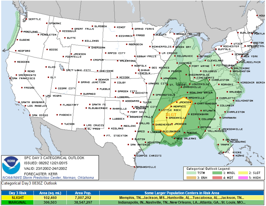
Whenever severe weather is possible in late December, our ears perk up a little bit, especially when we we’ve gone a long while without any severe storms. In this case, there is reason to be concerned, but there are far too many variables in play to raise the caution flag very high — at least at this point.
Here’s what we know:
Storms will be likely on Wednesday. The best chance for storms here appears to be during the afternoon through midnight time frame, possibly lingering into the wee hours of Thursday. It’s far too early to give a definitive explanation of when exactly to expect storms here, so just be on alert right now and watch for later updates as they become available.
*Some* of the ingredients needed for severe weather will be in place.
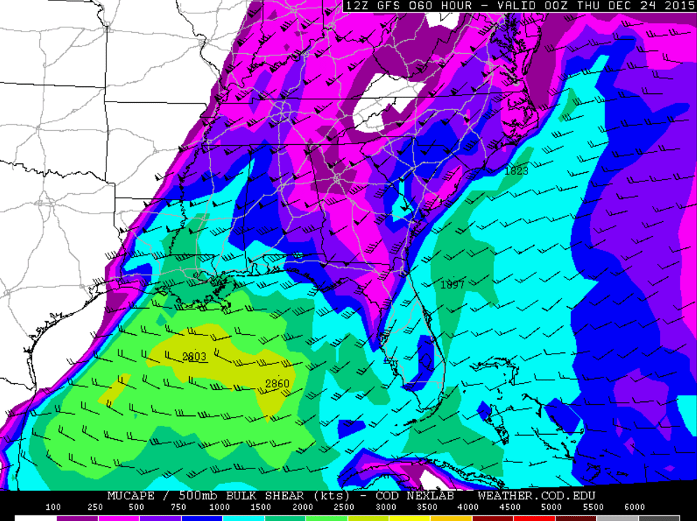
The above image shows the amount of CAPE, or “convective available potential energy,” that will be in place Wednesday evening, and the numbers being shown are fairly high for this time of year. The storm systems we had move through back in November lacked much, if any, CAPE, so they ended up being duds. This one has quite a bit more meat to it, especially southwest of here over areas of Alabama, Mississippi, and Louisiana, where severe weather concerns are bit higher than they are here. SPC has pointed out the potential for supercell development in that area, with storms moving NNE into the Tennessee Valley region. These storms could include large hail, damaging winds, and even tornadoes. One limiting factor *here* that could preclude severe storm development will be the amount of sunshine we receive during the day. The more sun we have, the more fuel the storms will have to work with. Right now, it looks like we’ll have a fair amount of cloud cover; those areas to our southwest look to have less clouds and more sun. Should we end up seeing fewer clouds, then we may have reason to worry.
There are a few other, more technical parameters suggesting severe weather potential here, but we won’t go into those right now. Models aren’t totally in agreement with this, and as such, we aren’t sounding the warning alarms yet — again, we’re only in a “Marginal Risk” area for the time being, which is the lowest of the Storm Prediction Center’s severe outlook categories. Just keep in mind that severe weather is a possibility as you prepare for Christmas gatherings and so forth. If you plan on travelling, it would probably be wise to avoid travel Wednesday afternoon, especially if you are heading southwest to those areas where severe weather looks more favorable. It might be best to leave either Tuesday afternoon/evening or very early Wednesday before the storms get going — or wait until Thursday morning before departing.
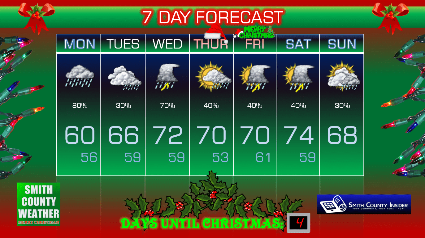
Christmas Eve looks mainly dry right now, with more showers and thunderstorms becoming possible on Christmas, although severe weather is, thankfully, not expected during that time. It will be warm, however, so mentally adjust for that — it won’t feel like Christmas, by any means (unless you’re from Florida).
Extended:
This forecast is brought to you by Smith County Weather. You can ‘LIKE’ Smith County Weather on Facebook and/or follow @SmithCountyWx on Twitter for the latest weather updates pertaining to Smith County, TN.


