


Thursday, January 21st, 2016 — 8:20 PM
ALERT: Smith County Schools will be CLOSED again tomorrow (Friday, January 22nd) due to the threat for winter weather.
Overnight — Widespread rain; a rumble of thunder possible. Low: 35°. Winds ENE at 10 to 15 mph, with gusts up to 20 mph possible.
Temperatures overnight will remain stagnant in the mid 30s — just barely warm enough that all precipitation will be in the form of rain.
Here’s a look at the big picture…

A low pressure system to our southwest is stirring up a whole mess of showers and thunderstorms across areas of Louisiana, Mississippi, and Alabama. For an idea of just how strong this system is, they’re dealing with tornado warnings in lower Mississippi while Arkansas is beginning to see snow. The latter of those two is what we’re concerned about here.
As this low pushes closer to our area, rain showers will filter in.
HRRR Loop (through 9 AM):

Scattered showers (and perhaps a rumble of thunder or two) will be likely all night and into tomorrow morning as the area of low pressure moves closer to us.
Rain will likely continue through the late morning hours, but this is where things will begin to get tricky.
First…
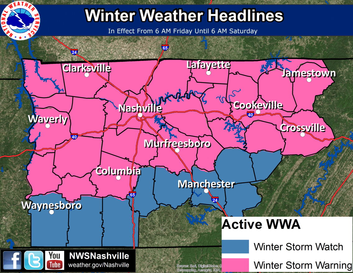
A Winter Storm Warning is in effect between 6 AM Friday and 6 AM Saturday. This replaces the Winter Storm Watch that was issued issued yesterday evening. According to the text of the warning, snow and ice build up on roads and bridges will make driving conditions hazardous, with 3 to 5 inches of snow accumulation possible. There could also be some light ice accumulation (less than a tenth of an inch) as well.
So, how much snow could we receive (yes, it was in the warning text, but it’s a bit more complicated than that)?
Well, that depends on when the transition from rain to snow will occur, which hinges on our temperatures. The later in the day temperatures fall to the freezing mark, the later the transition to snow will occur, and the less accumulation we’ll see. Again, wherever that low ultimately tracks will determine how quickly our temperatures fall.
Latest model indications are that the transition may occur close to noon, possibly even during the late morning hours as a wintry mix. Our National Weather Service office in Nashville posted this timeline a short while ago:
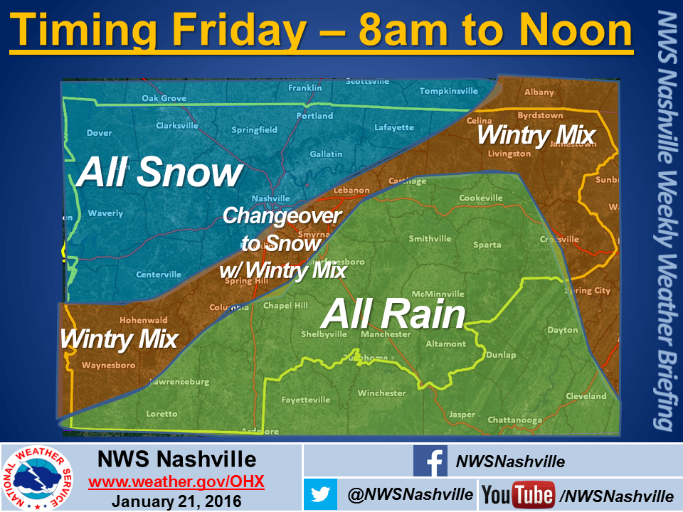
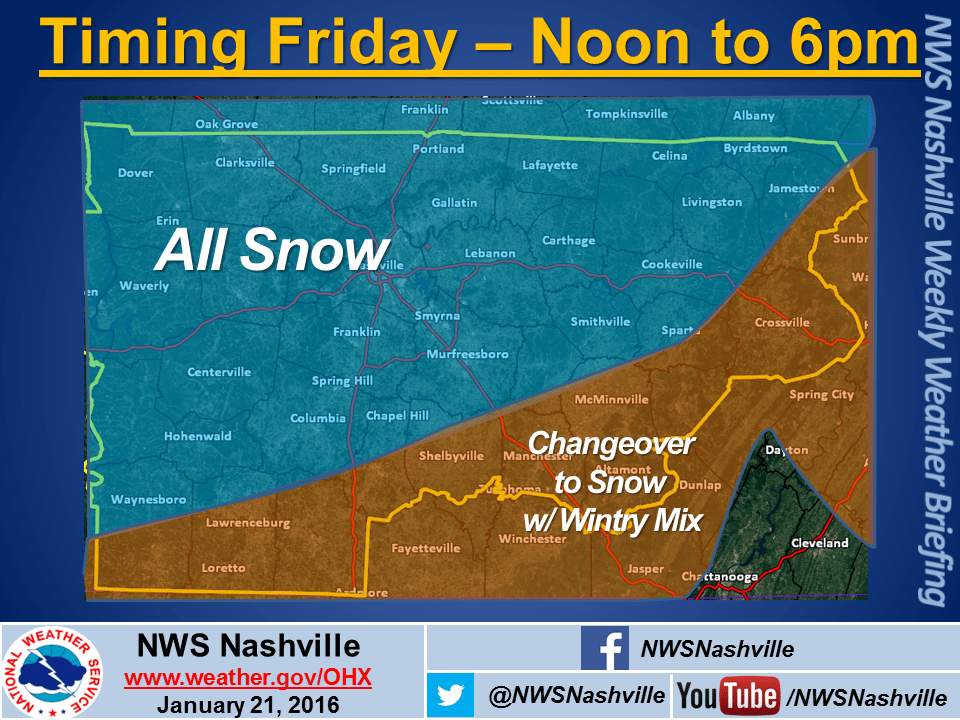
Earlier today, models were hinting at a later changeover, occurring during the afternoon to perhaps even as late as after sunset. Again, things have changed. Let’s take a look.
This was the NAM 4km model run at noon today, showing what radar may look like at noon tomorrow:

Here’s the CURRENT run of the NAM 4km, also showing our conditions at noon tomorrow:

As you can clearly tell, there’s a pretty significant difference here. Earlier, it looked as though the transition to snow would be getting close at noon, but it was likely still another two or three hours away from happening. Now the NAM 4km is suggesting it will already be snowing at noon, with the freezing line (32°) right on our door step. In fact, the old run essentially looks the same for the noon hour as this new one does at 9 AM.
This was the old GFS model run from 6 AM this morning, valid for noon tomorrow:

Here’s the latest run, also valid for noon tomorrow:
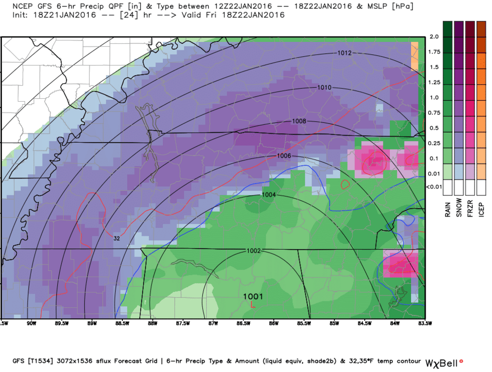
Not much has changed with the GFS, although it’s worth noting that even this latest run is several hours old. The newest one coming out in a little while may tell a different story (or it may not). Even still, both runs favor an early transition occurring around noon, with the latter one maybe just a wee bit sooner.
We couldn’t show you this before because it only updates once an hour and only shows 15 hour intervals at a time (compared to several days with the others), but here is the latest HRRR run for 9 AM tomorrow (for an animated version, scroll back towards the top):
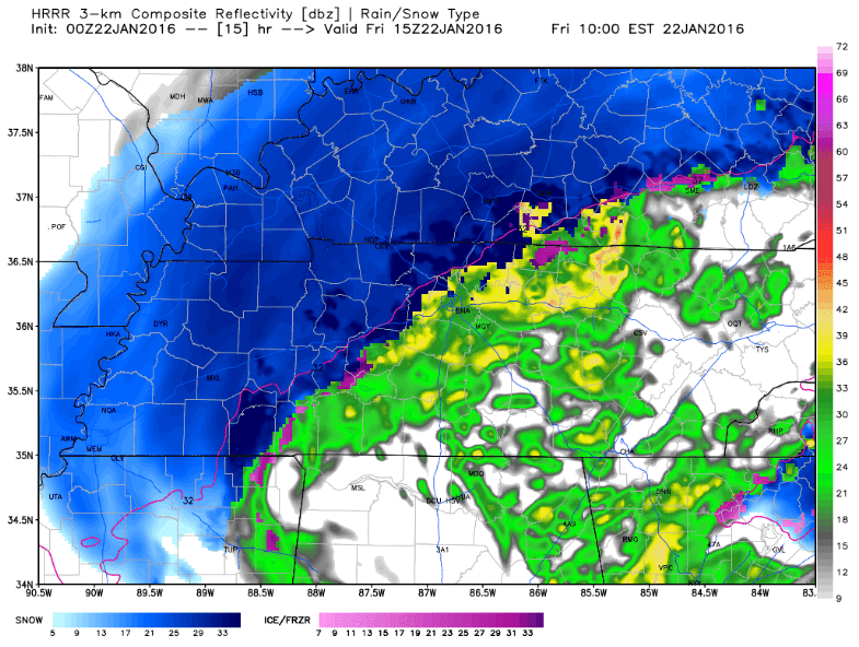
This is one of our favorite models, because it updates more often than the others and generally shows a more accurate (though not always precise) picture of what will happen. Even it hints at a transition to snow occurring perhaps during the late morning hours or around noon.
Others models we won’t show are also favoring this earlier transition to snow.
Bottom line: Compared to earlier, there’s now a bit more confidence with the timing of when rain will transition over to snow tomorrow. The noon hour is what we’re watching. Of course, that could change, so stay tuned for later updates.
As far as how much snow we could receive, here’s the latest rough estimate from NWS:

These estimates have been increased a tad from earlier, although given the latest model trends, they may need to be upped a little more. We’ll see. Right now, we’re within in the 3″ to 4″ range.
Summary: Rain showers will be persistent through much of the night and into tomorrow morning. Latest model guidance suggests that we could begin to see a changeover to a mix of wintry precipitation as early as the late morning hours, with snow becoming likely sometime around noon. These times are not set in stone and could very well change, but there is at least a little something to be said about models finally coming to agreement. Projected snow totals may need to be adjusted if these trends continue.
Also of note: this may not be a straight rain-to-snow transition. There could be some sleet or even freezing rain beforehand, so keep that in mind. There is high confidence, however, that this will primarily be a snow event, unlike Wednesday’s epic sleet-maker.
…and one more thing: Because the ground will be a few degrees above freezing, plus wet from all the rain, it may take a while for snow to begin accumulating. This could affect how much snow actually accumulates, although with models currently trending the way they are, this may not matter a whole lot overall.
Snow showers may persist into the early morning hours of our Saturday before tapering off. With cloudy skies and high around freezing, little melting will take place, so if you’re worried about being snowed in for a day or two, you might want to consider making a run to the store early tomorrow morning just as a precaution, although it would be wise to get any and all errands done by noon, at the latest. Sunday will be mostly sunny and a bit warmer, with a high around 40°. That should at least make a dent with road problems that may develop.
We’ll continue to keep you updated through the Smith County Weather page on Facebook and Twitter, so follow along for the latest details as they become available.


